Polymap 3.1.0
 PolyMap is a desktop mapping software that allows you use your own data to customize the maps supplied with the application.
|
PolyMap is a desktop mapping software that allows you use your own data to customize the maps supplied with the application.
Use the built-in spreadsheet to enter data or paste it from other Windows applications. Alternatively, you can use the import feature to bring in data from external spreadsheets, text, or database files.
The Map Presentation Wizard gives you a step-by-step process to customize your map and the map's legend. Any data in a spreadsheet column may be utilized for labeling.
You may use a set of geographic layers in different formats (state and county boundaries, five-digit ZIP codes, U.S. and state highways, cities, rivers, and lakes) to add details and create your new thematic map.
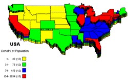
For instance, state and county boundaries can be "extruded" to 3D prisms, shaded in color, "sprayed" with a dot-density distribution, embedded with individual pie and bar charts, or placed into a matrix for portfolio analysis. New custom point layer can be added to the maps. Maps and spreadsheets may be printed with anyWindows-compatible printer.
Maps can be exported to Bitmap format (.bmp) enhanced Metafile (.emf) and JPEG (.jpg). PolyMap send JPG Bitmaps of the maps as attachment, to any e-mail address using MAPI compatible e-mail clients like Outlook Express or Netscape Communicator.
This trial version will function for only 30 days and comes with only a fraction of the maps available in the registered edition. Additional sample maps and a manual as pdf file are available from the PolyMap Website.
Requirements
64 MB RamLimitations
tags![]() the maps county boundaries maps and and county state and use the the map
the maps county boundaries maps and and county state and use the the map

Download Polymap 3.1.0
Purchase: ![]() Buy Polymap 3.1.0
Buy Polymap 3.1.0
Similar software
 Polymap 3.1.0
Ambiente Informatica Ltda
PolyMap is a desktop mapping software that allows you use your own data to customize the maps supplied with the application.
 WEB MAPS 1.0
SharewareLab
WEB MAPS allows you to search maps of any country, state, city or province.
 Versamap for Windows 3.01
Versamap
Versamap draws outline maps on 14 map projections.
 Stitch Maps 2.40
Petr Bezdecka
The maps used as basis for the assembly were either created by scanning templates, or by exports from digitalized maps.
 Surfer 2.0.1
Golden Software Inc
Surfer is a contouring and 3D surface mapping program that runs under Microsoft Windows.
 MapViewer 7.1.1767
Golden Software Inc
MapViewer is an affordable mapping and spatial analysis tool that allows you to produce publication-quality thematic maps easily.
 GridImp 2.4
Winwaed Software Technology
Imports gridded data into Microsoft MapPoint, to produce attractive data maps that resemble contour maps.
 Single State Mapper 1.0
Winwaed Software Technology LLC
Single State Mapping Tool lets you create maps of individual states with Microsoft MapPoint 2002 or 2004.
 Business Maps 1.1
direct print
Business Maps is an application that allow you to enter the phone number of a US business and get immediately the name of the business, the address, the latitude/longitude values of the location and a street map showing the locality.
 Grid Imp 2.2
Winwaed Software Technology
Grid Imp - imports gridded data into MS-MapPoint, to produce attractive data maps.