VIGps 1.0
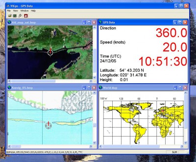
 VIGps is a program that will allow you to see route lines and maps.
|
VIGps is a program that will allow you to see route lines and maps.
GPS Navigator with using a scanned maps and possibility to open a lot of maps together.
How to use it:
Hints:
VIGps features
Limitations
Requirements
tags![]() gps data scanned maps you can speed direction route line see your the map gps device calibration points your gps direction and button show and route
gps data scanned maps you can speed direction route line see your the map gps device calibration points your gps direction and button show and route

Download VIGps 1.0
Purchase: ![]() Buy VIGps 1.0
Buy VIGps 1.0
Similar software
 VIGps 1.0
Valeri Vlassov
VIGps is a program that will allow you to see route lines and maps.
 Cartopro Evolution 21.10.2006
Alain Sigrist
Cartopro Evolution is the precision application you'll need for your GPS.
 MSN Password Sniffer 1.0
mythusoft
MSN Password sniffer is a useful and handy utility that can capture MSN passwords.
 GPSMap 2.11
Viking Informatics Ltd.
GPSMap displays your position on a user-uploaded maps using a Bluetooth-capable GPS receiver.
 GPSeasyPC 1.0
Pdawin.com
GPSeasyPC is easy to use map application for Windows, it use raster maps which are scanned by the user.
 OziExplorer 3.95.4n
Des & Lorraine Newman
OziExplorer is interactive, it allows you to work, on your computer screen, with digital maps that you have purchased or scanned yourself.
 iPoint 1.1
iTravel Tech
iPoint application is a location-based database using any map in jpeg format.
 Chameleon Clock 5.1
Jury Gerasimov
Chameleon Clock is a desktop clock which purpose is to be useful, user-friendly, and beautiful.
 Parity Plus 2.1
DataBull
Parity Plus is one of the most powerful Stock Charting and Technical Analysis software application available on the market.
 Stitch Maps 2.40
Petr Bezdecka
The maps used as basis for the assembly were either created by scanning templates, or by exports from digitalized maps.