Versamap for Windows 3.01
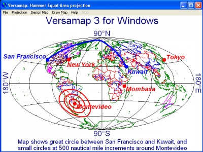
 Versamap draws outline maps on 14 map projections.
|
Versamap draws outline maps on 14 map projections. The program allows users to print publication quality maps on any printer supported by Windows; and to export your maps in vector graphics (DXF, WMF, ASCII, CGM) and bitmap (BMP) formats.
Versamap is supplied with digital maps from the Versamap Micro World Database, which contain boundaries for the new countries that have formed from the Soviet Union and Yugoslavia, for Eritrea, for Canadian Provinces, and for Australian States.
More detailed digital maps from the CIA's World Data Bank II and from the USGS Digital Line Graph database may be purchased from the author. Individual geographic features, such as coastlines, rivers, islands, and political boundaries, can be plotted from these digital map databases.
The program allows users to plot their own data (as lines or symbols) in a simple ASCII format, and to display labels next to their data points.
Text may be added to maps using any Windows font. Each text string can have a different font, and can be rotated in 1 degree increments.
The program plots Great Circles between user selected endpoints, and reports course and distance at points along the Great Circle. Versamap also reports map parameters and scale errors at selected points on the map.
Versamap is designed to plot outline maps of areas larger than about 200 miles (320 km) on a side. The program is not designed to plot maps of small areas, such as city maps.
Versamap requires Windows 3.1 or higher, and has an uninstall option that allows you to remove the program from your hard drive.
Limitations
tags![]() from the the program maps from digital maps allows users program allows outline maps
from the the program maps from digital maps allows users program allows outline maps

Download Versamap for Windows 3.01
![]() Download Versamap for Windows 3.01
Download Versamap for Windows 3.01
Purchase: ![]() Buy Versamap for Windows 3.01
Buy Versamap for Windows 3.01
Similar software
 Versamap for Windows 3.01
Versamap
Versamap draws outline maps on 14 map projections.
 Surfer 2.0.1
Golden Software Inc
Surfer is a contouring and 3D surface mapping program that runs under Microsoft Windows.
 WEB MAPS 1.0
SharewareLab
WEB MAPS allows you to search maps of any country, state, city or province.
 Polymap 3.1.0
Ambiente Informatica Ltda
PolyMap is a desktop mapping software that allows you use your own data to customize the maps supplied with the application.
 Stitch Maps 2.40
Petr Bezdecka
The maps used as basis for the assembly were either created by scanning templates, or by exports from digitalized maps.
 GPS2CAD 3.5
AzTechSoft
GPS2CAD allows you easily and inexpensively use recreational-grade GPS units to collect field information and plot it in their CAD software.
 iPoint 1.1
iTravel Tech
iPoint application is a location-based database using any map in jpeg format.
 OziExplorer 3.95.4n
Des & Lorraine Newman
OziExplorer is interactive, it allows you to work, on your computer screen, with digital maps that you have purchased or scanned yourself.
 VIGps 1.0
Valeri Vlassov
VIGps is a program that will allow you to see route lines and maps.
 MapViewer 7.1.1767
Golden Software Inc
MapViewer is an affordable mapping and spatial analysis tool that allows you to produce publication-quality thematic maps easily.