TRANSDAT 20.37
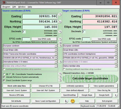
 TRANSDAT is a useful application that executes coordinate transformations with and without changing the geodetic reference system (datum shift) in high quality and with heigh performance.
|
TRANSDAT is a useful application that executes coordinate transformations with and without changing the geodetic reference system (datum shift) in high quality and with heigh performance.
With TRANSDAT these world wide coordinate transformations and Reference System transformations are available:
TRANSDAT is appropriate for the keyboard input of coordinates and for the treatment of coordinate files in the Text, dBase, ArcShape and ArcGenerate format (with Shape Viewer). All actions are stored in a log file.
Self installing Network ability, usage as DLL in own applications and batch processing is possible. A programmable GPS interface receives satellite coordinates for subsequent treatment in the program.
You will find a complete list of the coordinate and reference systems supported by the program in the internet or after downloading of the programs free test version.
TRANSDAT features
Limitations
tags![]() reference systems and reference coordinate and the program world wide geodetic reference bursa wolf for the text dbase with helmert systems can and geodetic dbase arcshape
reference systems and reference coordinate and the program world wide geodetic reference bursa wolf for the text dbase with helmert systems can and geodetic dbase arcshape

Download TRANSDAT 20.37
Purchase: ![]() Buy TRANSDAT 20.37
Buy TRANSDAT 20.37
Similar software
 TRANSDAT 20.37
Killet Softwareentwicklung GbR
TRANSDAT is a useful application that executes coordinate transformations with and without changing the geodetic reference system (datum shift) in high quality and with heigh performance.
 AllTrans 2.321
Hans-Gerd Duenck-Kerst
AllTrans can be used for world wide professional coordinate transformations between international and national coordinate systems with or without geodetic datum change.
 Coordinate Calculator 1.2.0
RockWare USA
Coordinate calculator is a freeware application which will help you convert the coordinates of a point from one geographic coordinate system to a second geographic coordinate system interactively.
 Tralaine 5.18
RockWare USA
Tralaine was designed to help with the conversion of geographic coordinates in data files from one geographic coordinate system to another; latitudes and longitudes to State Planes or State Planes to UTM's for example.
 SEVENPAR 15.16
Killet Softwareentwicklung GbR
Purpose of the program SEVENPAR is to produce a set with seven Helmert transformation parameters valid for an specific area, with which then arbitrary points of the area can be transformed from one coordinate system into another with high accuracy.
 Coordinate Marker 2006 2.0
CADD Productivity
The Coordinate Marker application works with AutoCAD 2006 to quickly create coordinate notations in your drawing.
 Coordinate Marker 2002 2.0
CADD Productivity
The Coordinate Marker application works with AutoCAD 2002 to quickly create coordinate notations in your drawing.
 GPS2CAD 3.5
AzTechSoft
GPS2CAD allows you easily and inexpensively use recreational-grade GPS units to collect field information and plot it in their CAD software.
 Canvas GIS Mapping Edition 9.0.4
ACD Systems
The CANVAS 9 GIS Mapping Edition adds native support for Geographic Information System (GIS) data to Canvas.
 Function Grapher 3.9.2
GraphNow
Function Grapher is a easy-to-use software for 2D, 2.