SEVENPAR 15.16
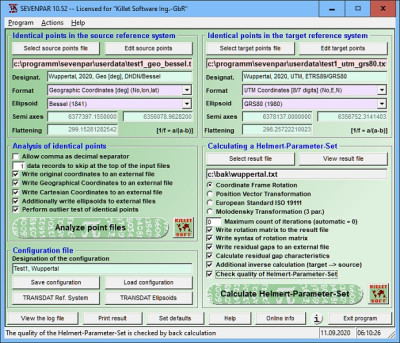
 Purpose of the program SEVENPAR is to produce a set with seven Helmert transformation parameters valid for an specific area, with which then arbitrary points of the area can be transformed from one coordinate system into another with high accuracy.
|
Purpose of the program SEVENPAR is to produce a set with seven Helmert transformation parameters valid for an specific area, with which then arbitrary points of the area can be transformed from one coordinate system into another with high accuracy.
The Helmert transformation parameters are computed with a set of individual identical points. Those are points with known coordinates in both coordinate systems. For the computation at least three identical points must be present. In practice you will be anxious to use more identical points than those three necessities.
Cartesian coordinates or geographical coordinates with ellipsoidal height using the ellipsoid dimensions are suitable. Identical measuring points of higher order can be usually inquired or referred by the official institutions for measurement.
SEVENPAR is a tool that allows you to transform parameters.
The necessary ellipsoid half-axis are available in the program for the selection from lists. There are altogether to determine seven parameters, i.e. three translations, three rotations and a scale constant. The parameters are calculated by the compensation according to the method of the smallest squares (L2 norm, Helmert transformation).
Therefore must be dissolved a formula system with seven equations and seven unknown quantities. The coordinates of the identical points are tested intensively on outliers and deviations by different statistic procedures.
The quality of the computed seven Helmert parameters is documented by a cleavage matrix and by the computation of the middle, maximum and root mean square (RMS) deviations.
The seven Helmert parameters are calculated in the three most usual standards. Those are the Coordinate Frame Rotation, the Position Vector Transformation and the European Standard ISO 19111.
tags![]() identical points helmert transformation parameters are seven helmert the computation are calculated helmert parameters for the those are transformation parameters the program with seven
identical points helmert transformation parameters are seven helmert the computation are calculated helmert parameters for the those are transformation parameters the program with seven

Download SEVENPAR 15.16
Purchase: ![]() Buy SEVENPAR 15.16
Buy SEVENPAR 15.16
Similar software
 SEVENPAR 15.16
Killet Softwareentwicklung GbR
Purpose of the program SEVENPAR is to produce a set with seven Helmert transformation parameters valid for an specific area, with which then arbitrary points of the area can be transformed from one coordinate system into another with high accuracy.
 EasyTrans 1.27
Dr. Mathes
EasyTrans stands for an 'all-in-one' application to transform coordinates.
 AllTrans 2.321
Hans-Gerd Duenck-Kerst
AllTrans can be used for world wide professional coordinate transformations between international and national coordinate systems with or without geodetic datum change.
 TRANSDAT 20.37
Killet Softwareentwicklung GbR
TRANSDAT is a useful application that executes coordinate transformations with and without changing the geodetic reference system (datum shift) in high quality and with heigh performance.
 FlashPoints 1.0
DeliCAD
FlashPoints is a tool for creating and managing points Groups (topographic points for example).
 Approximator Line 1.2.577
oleg's tsulun
Approximator Line is an application which allows to synthesize approximation function of one argument.
 ZigZag 1.3
Palam Software, Inc.
ZigZag is a handy tool to plot and explore math functions.
 Coordinate Calculator 1.2.0
RockWare USA
Coordinate calculator is a freeware application which will help you convert the coordinates of a point from one geographic coordinate system to a second geographic coordinate system interactively.
 Precision Image Digitizer 1.1
Michael Robinson
With Precision Image Digitizer you can trace and record the coordinates of your selected points in a JPG, GIF, or BMP.
 TerrainSectionsPro2X 2.2
Cadhedral
With TerrainSectionsPro2X which is an AutoCAD add-on, you can create terrain sections from geodetic points(heights) in the drawing.