RapidDXF 4.0
 RapidDXF is a program that will allow you to import topographic datas in your CAD system.
|
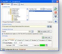
RapidDXF is a program that will allow you to import topographic datas in your CAD system. It reads ASCII (text) files of coordinates and creates DXF (version 12) files. The DXF files so created are usable in any CAD software.
Coordinates files can be GPS files, XYZ files, generaly files with the following format:
Number, X (East), Y (North), Z (Elevation), Description. Moreover, a special Code field can be processed for polyline creation.
tags![]()

Download RapidDXF 4.0
Purchase: ![]() Buy RapidDXF 4.0
Buy RapidDXF 4.0
Similar software
 RapidDXF 4.0
DeliCAD
RapidDXF is a program that will allow you to import topographic datas in your CAD system.
 Points Import for IntelliCAD 1.0
SYCODE
Points Import for IntelliCAD is a Point Text file import plug-in for IntelliCAD powered applications.
 SceneDraw 1.0
AK Corp and Delicad
SceneDraw is an investigative tool, for police and private investigators that need to survey and diagram scenes for criminal and civil litigation.
 FlashPoints 1.0
DeliCAD
FlashPoints is a tool for creating and managing points Groups (topographic points for example).
 Precision Image Digitizer 1.1
Michael Robinson
With Precision Image Digitizer you can trace and record the coordinates of your selected points in a JPG, GIF, or BMP.
 Bmp2Mc 1.15
MR-Soft
Bmp2Mc is a useful add-in for Mastercam v8 and v9 which reads the files in bitmap format (BMP grayscale) and converts into 3d toolpath.
 FileFindString 1.0
Sophtware Kode Werks
FileFindString is an application that will searche through numerous ASCII files for text strings that you specify.
 Easy Button Creator 2.0
Image Tools Group
Easy Button Creator is intended for easy creation of 3D buttons.
 ASCII Key 1.3
Ulrich Muehlenhoff
ASCII Key is a tool for comparing the contents of two text files, identifying duplicate records and filtering.
 CadLib 1.1.14
Wout Ware
With this library AutoCad files can be created from your own .